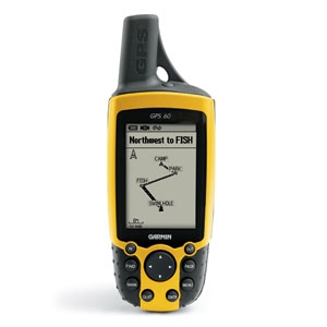
Garmin GPS60
I‘m usually a big fan of technology, I was always worried about getting a GPS, firstly in case it took the fun out of navigating on the hill and secondly in case I started to rely on it and forgot how to read a map and thirdly I didn’t really see the point in getting one, I had always managed to get to where I had wanted to go without too many problems.
This all changed on a misty day in December 2005, we had just climbed up Malham Cove in the beautiful Yorkshire Dales and started off across the moorland when the mist descended and we couldn’t see our hand in front of our faces. This made navigation almost impossible, luckily the path was pretty clear and we managed to navigate our way safely below the mist and back to the campsite.
I wont lie it was quite scary, not knowing exactly where we were and not being able to navigate using the landscape around us, I decided that it was time for a backup plan in case it happened again, so after a couple of weeks I decided I’d get a GPS.
After a bit of research and looking for a deal I came across the Garmin GPS 60 which was on offer for just a few quid more than the basic Garmin etrex and offered a few extras (including the PC link cable) over it’s smaller brother so I decided it was too good an opportunity to miss. The GPS60 is packed full of features which you can read about here so I’ll not go into all of them. Plus there are umpteen new models out now that do even more, and to be totally honest I only really use the basic features.
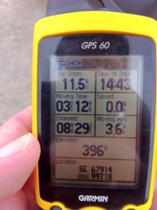
It’s been on just about every walk with me over the last few years, whether it’s been attached to my rucksack or stuffed in the top pocket, I can’t think of a walk I’ve done without it being there. During the walks it’s left on for the duration (and sometimes even the car journey home when I forget to turn it off) and used it for tracking our speed, distance covered and occasionally confirming our location when on a particulalry tricky bit of route navigation.
As far as I’ve been able to tell, over the last few years it’s been spot on with its location and positioning with accuracy usually around 3ft. I’ve not had any problems with it loosing signal, other than when going indoors or through really thick woodland. After each walk I download the track to Tracklogs and the route it draws on the map is usually spot on.
The GPS 60 weighs 198g including the batteries and is pretty compact despite the external arial. It’s bright yellow casing is waterproof and extremely tough, I’ve lost count of the number of times that I’ve dropped, kicked and bashed the unit against all sorts of surfaces and apart from the odd scratch it’s still in great condition. The buttons are chunky enough to use with gloves on and the rubber is grippy enough to hold even in the rain.
The screen is easy to read in just about all conditions, It’s got a light behind which you can adjust depending on how light/dark it is and that combined with being able to adjust the contrast makes the screen readable pretty much all of the time, although having the light on does decrease the battery life quite a bit. You can customise each screen with everything from time, speed, average speed, location, sunset, sunrise and just about every other bit of info you could ever want to know while out walking.
Speaking of batteries I bought some duracell rechargeable batteries not long after my first trip out in the snow with the GPS60, the normal Duracell coudln’t handle the cold so were out of juice after a couple of hours, unlike the rechargeable which seem to last for ever, during the Coast to Coast the batteries were great and I didn’t have to recharge them much over the 13 days.
The GPS 60 can store plenty of routes before you have to delete them, I managed to get the entire Coast to Coast track log on their without having to delete any during the walk. Downloading the logs to your computer is straightforward, simply plug it in with the cable that’s provided, turn it on then use the software of your choice (there is some included but I prefer Tracklogs or Google Earth), once imported you can then safely delete them from the GPS freeing up more space for future walks.
Route planning works pretty much the same but the other way round, plan your walk using your favourite software then upload to your GPS, allowing you to navigate using the screen and well timed beeps. I’ve tried it a couple of times and it works well but it does take the fun out of the walk.
It’s essential you learn to use your GPS properly as they aren’t always perfect and if you don’t know how to read it you can easily go wrong, I’ve often seen people relying on the arrow on screen and going off in completely the wrong direction, most recently on the Coast to Coast where we saw a couple go wrong a few times due to their GPS not updating quick enough and they ended up going in the wrong direction.
So after being reluctant to get a GPS, I now never leave for a walk without it, if nothing else it satisfies the geek in me and lets me log, track and share all of my routes, plus gives me the emergency backup in case things go wrong on the hill. I’ve also tried various bits of software on my Iphone but the battery life and accuracy lets it down a little so personally I don’t think you can beat having a dedicated GPS unit…..along with your map and compass of course.


Follow Me!